

Jammu Kashmir Map for Tourists: Cities, Valleys & Roads
Table of Contents
- 1 Understanding the Jammu Kashmir Map
- 2 Jammu Region on the Jammu Kashmir Map
- 3 Kashmir Valley on the Jammu Kashmir Map
- 4 Major Cities & Towns on the Jammu Kashmir Map
- 5 Road Network & Highways on the Jammu Kashmir Map
- 6 Distance, Time & Route Planning Using the Map
- 7 Tourist Seasons Explained Through the Jammu Kashmir Map
- 8 Tourist Permits, Restricted Areas & Border Zones
- 9 Digital vs Printed Jammu Kashmir Maps
- 10 Common Mistakes Tourists Make While Reading the Jammu Kashmir Map
- 11 Sample Map-Based Tourist Itineraries
- 12 Final Thoughts
- 13 Frequently Asked Questions
The Jammu Kashmir map helps tourists understand cities, valleys, road routes and travel regions across the Union Territory. From Jammu to the Kashmir Valley and Ladakh highways, this guide explains how to read and use the Jammu Kashmir map for smarter trip planning.
For anyone planning a trip to North India, understanding the jammu kashmir map is not optional it is essential. Jammu and Kashmir is not a compact destination you can explore casually.
It is geographically complex, spread across plains, hills, high-altitude valleys and mountain passes, each with different travel seasons, road conditions and accessibility.
Tourists often underestimate distances in this region. A place that looks close on Google Maps can take 6-8 hours due to winding mountain roads,weather conditions, or traffic restrictions.
This is where a tourist-focused Jammu Kashmir map becomes critical. Unlike generic political maps, a travel map highlights cities, valleys, road connectivity, tunnels and seasonal routes, helping visitors plan realistic itineraries.
The region is broadly divided into three tourist-relevant zones:
- Jammu region (entry point, plains + pilgrimage routes)
- Kashmir Valley (lakes, valleys, hill stations)
- High-altitude road corridors connecting to Ladakh
Each zone behaves differently on the map. Jammu is well-connected by rail and national highways. Kashmir Valley relies heavily on mountain passes and tunnels. Snowfall, landslides, or security advisories can temporarily change routes something a tourist map clearly reflects.
Another reason tourists search for the jammu kashmir map is confusion around districts and valleys. Places like Gulmarg, Pahalgam and Sonmarg are not cities; they are tourist regions located within specific districts. A proper map clarifies this and prevents itinerary mistakes.
This guide breaks down the Jammu Kashmir map specifically for tourists, not students or exam prep. You’ll learn:
- How cities are positioned
- Where major valleys lie
- Which roads matter most for travel
- How to plan routes efficiently
If you’re visiting Kashmir for the first time, this map-based understanding alone can save you days of confusion, money and travel fatigue.
Understanding the Jammu Kashmir Map

To plan a smooth trip, tourists must read the jammu kashmir map differently from how students or exam-focused users do. A tourist map is not about boundaries alone it is about movement, accessibility, terrain and time.
This section explains how to interpret the map from a practical travel perspective, starting with the administrative structure and then moving into physical geography.
Administrative vs Tourist Regions
At an administrative level, the jammu kashmir map represents a Union Territory of India, divided mainly into two broad regions:
- Jammu region
- Kashmir Valley
While this division is political and administrative, it has direct consequences for tourists.
Jammu Region
On the map, the Jammu region lies in the south and is comparatively flatter at the start, gradually rising into hills. For tourists, Jammu functions as:
- The main entry point (rail + road)
- A transition zone between plains and mountains
- A base for pilgrims and hill tourism
Because of better infrastructure, travel here is usually faster and more predictable. When tourists look at the jammu kashmir map, Jammu appears as the “easy-access” side of the territory.
Kashmir Valley
The Kashmir Valley appears north of Jammu, surrounded by mountain ranges. From a tourist perspective, this region is:
- The core sightseeing zone
- More climate-sensitive
- Dependent on limited entry routes
This is where most travel planning mistakes happen. The map may show short distances, but mountainous terrain dramatically increases travel time.
Why Districts Matter for Tourists
A common tourist mistake is ignoring district boundaries on the Jammu Kashmir map. Districts are not just administrative units they affect permits, hotel availability, policing and travel duration.
Key reasons districts matter:
- Permits & Advisories
Certain areas near borders or higher altitudes fall under stricter monitoring. Knowing the district helps tourists avoid restricted zones unintentionally. - Hotel Licensing & Availability
Hotels are regulated at the district level. Some districts have limited licensed accommodations, which affects pricing and availability during peak season. - Realistic Travel Time
District boundaries often align with natural terrain changes. Moving from one district to another may mean crossing a pass, tunnel, or river adding hours to the journey.
For example, Gulmarg and Pahalgam are both “near Srinagar” on paper, but they lie in different districts and opposite directions. A proper reading of the jammu kashmir map highlights this clearly.
Physical Geography on the Map
The second layer tourists must understand on the jammu kashmir map is physical geography. This region’s terrain directly controls weather, road access and sightseeing feasibility.
Mountains
Mountains dominate the map visually. They:
- Surround the Kashmir Valley
- Create natural travel bottlenecks.
- Cause seasonal road closures.
For tourists, mountains explain why routes are indirect and why some places disappear from itineraries in winter.
Valleys
Valleys are the most tourist-friendly zones and appear as relatively open spaces on the map. Major tourist destinations are all valley-based because they:
- Have gentler terrain
- Support roads and hotels.
- Offer stable weather windows.
Understanding valley placement helps tourists group destinations efficiently and avoid backtracking.
Rivers
Rivers like the Jhelum are not just visual features. On the map, they indicate:
- Settlement patterns
- Road alignments
- Flood-prone areas during the spring melt
Tourist maps often follow rivers because roads do too.
Lakes
Lakes such as Dal Lake appear prominently on tourist maps because they anchor hotel zones, sightseeing circuits and city layouts. Their position helps tourists choose accommodation strategically.
Altitude Variations and Climate Zones
Altitude is the single most important hidden factor in the jammu kashmir map.
- Low altitude (Jammu region): Hot summers, mild winters, year-round access
- Mid altitude (Srinagar & nearby valleys): Pleasant summers, cold winters
- High altitude (Sonmarg, passes): Snowbound in winter, short tourist season
Two destinations may look close on the map but sit at very different altitudes, resulting in:
- Temperature differences
- Clothing mistakes
- Health issues (altitude sickness)
- Sudden route closures
Tourists who understand altitude layers on the jammu kashmir map plan better itineraries, pack correctly and avoid unrealistic day plans.
Key Takeaway for Tourists
A tourist-friendly reading of the jammu kashmir map combines:
- Administrative awareness (regions + districts)
- Physical geography (terrain + altitude)
- Practical travel logic (time, access, seasonality)
Once this foundation is clear, every other decision hotels, routes, sightseeing order becomes significantly easier and more reliable.
Jammu Region on the Jammu Kashmir Map

On the jammu kashmir map, the Jammu region occupies the southern portion of the Union Territory and plays a strategic role for tourists.
While many travelers focus primarily on the Kashmir Valley, understanding the Jammu region on the map is essential because it functions as the primary entry corridor, logistical base and transition zone between the plains of North India and the Himalayan landscape.
From a tourist perspective, the Jammu region is where most journeys into Jammu and Kashmir begin.
Jammu Region as the Gateway for Tourists
When viewed on the jammu kashmir map, the Jammu region appears less mountainous at the southern edge, gradually rising into hills as you move north. This geographical transition explains why Jammu is:
- Better connected by railways and highways
- Less affected by seasonal road closures
- Operational throughout the year
The city of Jammu is clearly marked as a transport hub on the map. It connects directly to NH44, the most important road artery for tourists traveling toward the Kashmir Valley.
This is why many itineraries officially start in Jammu, even if the main goal is Srinagar, Gulmarg, or Pahalgam.
For tourists arriving by train, Jammu is the last major railhead. From here, all further travel becomes road-based, making map awareness crucial.
Key Tourist Areas in the Jammu Region
Although often treated as a transit zone, the Jammu region includes several important tourist destinations that are clearly visible on a detailed jammu kashmir map.
One of the most prominent is Katra, the base town for the Vaishno Devi shrine. On the map, Katra sits northeast of Jammu city and attracts millions of visitors annually, making it a major accommodation and stopover hub.
Further north along NH44, hill destinations like Patnitop, Nathatop and Sanasar appear as elevated plateaus. These locations are important for tourists because they:
- Break long road journeys
- Offer scenic overnight stops.
- Provide a gradual altitude adjustment before entering the Kashmir Valley.
Eastern parts of the Jammu region, including areas like Bhaderwah, are also visible on the map but require more deliberate planning due to narrower roads and longer travel times.
Road Connectivity and Travel Logic
From a navigation standpoint, the Jammu region is the most predictable section of the jammu kashmir map. Roads are wider, fuel stations are frequent and mobile connectivity is relatively stable. This makes it ideal for:
- First-day arrivals
- Night halts
- Buffer days in itineraries
Tourists who rush through Jammu without acknowledging its position on the map often underestimate travel fatigue. A proper map-based plan uses Jammu as a staging area before entering the more terrain-sensitive Kashmir Valley.
Why the Jammu Region Matters on the Map
In tourist planning terms, the Jammu region is not just “below Kashmir” on the map. It is the foundation layer of any Jammu and Kashmir itinerary. Understanding its location, road flow and tourist clusters on the jammu kashmir map helps travelers:
- Schedule realistic arrival times
- Choose logical stopovers
- Avoid exhaustion before reaching the valley.
A well-read map makes the Jammu region work for your trip, not against it.
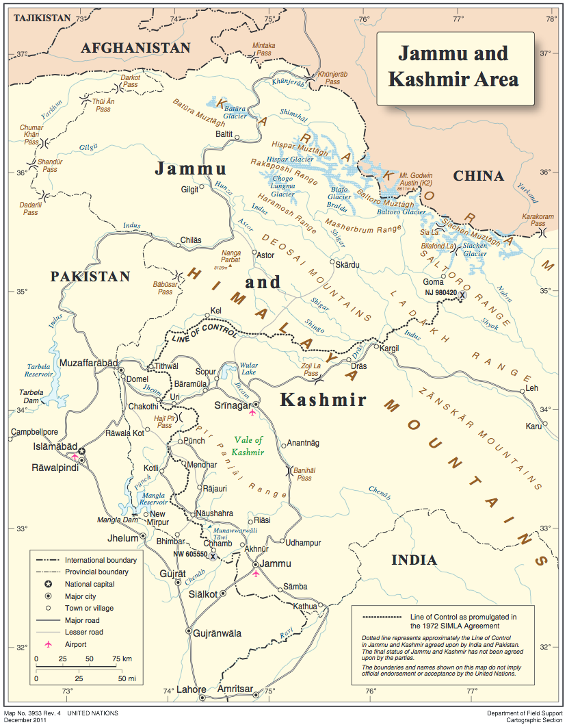
Kashmir Valley on the Jammu Kashmir Map

The Kashmir Valley is the focal point of tourism and the most closely examined area on the jammu kashmir map.
From a tourist’s perspective, this region represents the transition from logistical planning to experiential travel.
Understanding how the valley is positioned on the map is critical for route sequencing, accommodation choices and realistic daily planning.
Geographically, the Kashmir Valley appears as a bowl-shaped basin surrounded by mountain ranges.
This single feature explains many on-ground realities that tourists face limited entry routes, weather sensitivity and longer travel times despite short distances.
Geographic Placement of the Kashmir Valley
On the jammu kashmir map, the Kashmir Valley lies north of the Jammu region and is encircled by high mountains. There are only a few practical road corridors connecting it to the outside world. This geographic isolation makes the valley:
- Highly scenic
- Climatically distinct
- Logistically delicate
Unlike Jammu, where multiple alternate roads exist, the Kashmir Valley depends on specific tunnels and passes. Any disruption here affects the entire region’s movement, which is why map awareness is essential for tourists.
Srinagar: The Central Hub on the Map

At the center of the Kashmir Valley on the jammu kashmir map is Srinagar. Srinagar is not just the largest city it is the operational heart of tourism.
From a map-reading perspective:
- All major tourist routes radiate outward from Srinagar
- Most hotels, houseboatscand transport services are concentrated here.
- Day trips are designed based on Srinagar’s location.
Because of this centrality, tourists who stay in Srinagar gain maximum flexibility. The map clearly shows how destinations branch off in different directions, making Srinagar the most logical base.
Major Valleys and Tourist Zones
A tourist-oriented jammu kashmir map highlights valleys rather than just towns. Valleys define sightseeing clusters and travel logic.
- Gulmarg
Located northwest of Srinagar, Gulmarg sits at a higher altitude and is known for its meadows and winter sports. The map shows a relatively short road distance, but the steep ascent increases travel time. - Pahalgam
Positioned southeast of Srinagar, Pahalgam lies in a different district and requires a separate travel day. The map makes it clear that combining Pahalgam with Gulmarg on the same day is impractical. - Sonmarg
Northeast of Srinagar, Sonmarg sits close to high mountain passes. On the map, it appears close, but altitude and weather can restrict access.
Other valleys like Yusmarg and Doodhpathri also appear west and southwest of Srinagar, ideal for short excursions.
Districts and Travel Direction
The Kashmir Valley is divided into multiple districts and this division directly affects travel planning. On the jammu kashmir map, districts align with valley orientations. Moving between districts often means:
- Crossing rivers
- Navigating narrow mountain roads
- Losing time at checkpoints
Understanding district placement prevents itinerary overload and unnecessary backtracking.
Climate and Altitude Influence
The Kashmir Valley’s altitude range is moderate to high. On the map, this explains:
- Cooler summers compared to Jammu
- Snowfall in winter
- Seasonal inaccessibility of higher valleys
Tourists who understand this altitude layer on the jammu kashmir map pack appropriately, plan buffer days and avoid unrealistic winter routes.
Why the Kashmir Valley Section of the Map Is Crucial
For tourists, the Kashmir Valley on the jammu kashmir map is not just about beauty it is about precision. A clear map-based understanding allows travelers to:
- Choose the right base
- Group destinations logically
- Avoid rushed travel days.
- Adjust plans based on season and weather.
In Kashmir, the map is not a reference it is the itinerary itself.
Major Cities & Towns on the Jammu Kashmir Map
For tourists, cities and towns on the jammu kashmir map are not just dots indicating population centers. They represent transport hubs, accommodation clusters, administrative zones and logistical anchors.
Understanding where major cities and towns are positioned helps travelers decide where to stay, how to move and how to structure sightseeing days efficiently.
Unlike metro-based destinations, Jammu and Kashmir tourism depends heavily on a few strategically located cities, each serving a specific role.
Jammu: Southern Entry Hub
On the jammu kashmir map, Jammu appears in the southernmost section and functions as the primary gateway for road and rail travel. For tourists, Jammu is:
- The main rail-connected city
- A staging point before entering mountainous terrain
- A buffer zone for early arrivals or late departures
Many travelers use Jammu for overnight stays, especially when arriving late by train. Its location on the map explains why skipping Jammu entirely often leads to rushed or exhausting journeys.
Srinagar: Tourism Capital and Central Base
Srinagar occupies a central position in the Kashmir Valley on the jammu kashmir map. This positioning makes Srinagar the most important city for tourists.
From a practical standpoint:
- Most flights land here
- All major sightseeing routes branch outward
- Hotels, houseboats and tour services are concentrated here.
The map clearly shows that Srinagar minimizes travel time to Gulmarg, Pahalgam, Sonmarg and other valleys, which is why it is the preferred base for first-time visitors.
Anantnag: Southern Valley Connector
Located south of Srinagar on the jammu kashmir map, Anantnag acts as a gateway to southern Kashmir. It is especially relevant for tourists visiting Pahalgam and the nearby valleys.
Anantnag’s position makes it useful for:
- Breaking long travel days
- Accessing less crowded areas
- Exploring offbeat destinations
Baramulla: Northern Valley Anchor
On the northern side of the valley lies Baramulla, clearly marked on the map as a district and urban center. It supports tourism in:
- Gulmarg
- Tangmarg
- Nearby alpine regions
Baramulla’s placement helps tourists understand the northern route limits and avoid unnecessary detours.
Kupwara: Remote Northern Town
Further northwest, Kupwara appears close to the border regions on the jammu kashmir map. While not a mainstream tourist base, its location explains:
- Restricted travel zones
- Limited accommodation
- Increased permit sensitivity
Tourists benefit from recognizing Kupwara on the map to avoid accidental route planning into restricted areas.
Shopian: Orchard Belt Town
In southern Kashmir, Shopian is shown within the apple-growing belt. For tourists, Shopian’s relevance is seasonal, offering scenic countryside routes rather than major attractions.
Why Cities & Towns Matter on the Map
On the jammu kashmir map, cities and towns are decision points. They determine:
- Where roads converge
- Where fuel and medical facilities exist
- Where overnight stays make sense
Tourists who understand the city placement plan can smarter routes, avoid overextension and enjoy a smoother Kashmir experience.
Road Network & Highways on the Jammu Kashmir Map

For tourists, the road layer is the most important element of the jammu kashmir map. Unlike destinations with dense highway grids, Jammu and Kashmir relies on a limited number of strategic roads.
These routes determine where you can go, how long it will take and whether travel is possible at all during certain seasons.
Understanding the road network is essential for realistic itinerary planning.
National Highways: The Backbone of Travel
On the jammu kashmir map, National Highway 44 (NH44) stands out as the single most critical road.
It connects Jammu to Srinagar, cutting across mountains, tunnels and valleys. For tourists, NH44 is not just a highway it is the lifeline of Kashmir tourism.
Key characteristics visible on the map:
- Long, winding alignment through hilly terrain
- Strategic tunnels that bypass older mountain passes.
- Towns and rest stops are spaced along the route
Although the straight-line distance appears moderate, the map explains why travel times are long. Changes in altitude, traffic bottlenecks and weather conditions all influence movement along NH44.
Another important route visible on the map is the Srinagar-Leh road, which branches eastward from the Kashmir Valley.
While not always accessible year-round, its presence on the map signals high-altitude travel and seasonal planning considerations for tourists.
Tunnels & Mountain Passes
A detailed jammu kashmir map highlights tunnels and passes because they directly affect accessibility.
- Banihal Tunnel
This tunnel shortens travel time between Jammu and the Kashmir Valley and remains operational in most weather conditions. Its position on the map explains why winter travel has become more reliable. - Z-Morh Tunnel
Located on the route toward Sonmarg, this tunnel improves access to higher-altitude areas and extends the tourist season. - Zojila Pass
Marked as a high-altitude pass, Zojila appears vulnerable on the map. Tourists can instantly identify why this route closes in winter.
Understanding where tunnels replace passes helps tourists anticipate delays, closures, or alternative planning.
Key Tourist Routes from Srinagar
On the jammu kashmir map, Srinagar acts as the central road hub within the valley. Several key tourist routes radiate from it:
- Srinagar – Gulmarg (northwest)
- Srinagar – Pahalgam (southeast)
- Srinagar – Sonmarg (northeast)
These routes are short in distance but differ greatly in terrain. The map reveals elevation changes, forest zones and river crossings, helping tourists understand why combining multiple destinations in one day is impractical.
Secondary Roads & Scenic Drives
Beyond highways, the jammu kashmir map shows secondary roads that offer scenic value but slower travel. These routes are popular for:
- Photography
- Countryside exploration
- Offbeat destinations
However, tourists must recognize that secondary roads often lack fuel stations, restrooms and mobile connectivity.
Seasonal Impact on Roads
One of the most important insights the jammu kashmir map provides is seasonal accessibility. Roads at higher altitudes may disappear from practical use in winter. Snowfall, landslides and weather advisories can temporarily break connectivity.
Tourists who read the road network properly:
- Avoid unrealistic itineraries
- Build buffer days
- Choose safe travel windows
Why Roads Matter More Than Distance
In Jammu and Kashmir, roads not distance define travel. A well-read jammu kashmir map helps tourists replace assumptions with realism, ensuring safer, smoother and more enjoyable journeys across this unique landscape.
Distance, Time & Route Planning Using the Map
For tourists, the most common mistake when reading the jammu kashmir map is assuming that distance equals travel time. In Jammu and Kashmir, this assumption fails more often than it works.
The region’s terrain, altitude changes and limited road network mean that time planning is far more important than kilometer counts.
A tourist-friendly reading of the map focuses on how long a route takes, not how short it looks.
Why Distance Is Misleading on the Jammu Kashmir Map
On the jammu kashmir map, many destinations appear close together. For example, Gulmarg, Pahalgam and Sonmarg all seem clustered around Srinagar. However, the map also shows:
- Mountain barriers
- River alignments
- Directional divergence of roads
These features explain why a 50-70 km drive can take 3 to 4 hours or more. Sharp curves, steep gradients and security checkpoints slow movement even in good weather.
Tourists who plan purely by distance often overload a single day, resulting in rushed sightseeing and fatigue.
Understanding Route Direction & Clustering
A key benefit of using the jammu kashmir map correctly is learning directional planning. From Srinagar, major tourist routes branch out in different directions, not in a circular loop.
- Gulmarg lies to the northwest.
- Pahalgam lies to the southeast.
- Sonmarg lies to the northeast.
The map clearly shows that these destinations do not lie on the same route. This is why experienced planners allocate separate days for each, even though distances seem manageable.
Grouping destinations based on direction rather than proximity is one of the most important map-based skills for Kashmir travel.
Realistic Travel Time Estimation
When estimating travel time using the jammu kashmir map, tourists should factor in:
- Terrain: Flat roads in Jammu vs mountainous roads in the valley
- Altitude changes: Slower speeds at higher elevations
- Traffic patterns: Tourist rush hours near Srinagar
- Checkpoints & stops: Especially near sensitive areas
As a rule of thumb, mountain travel in Kashmir averages 20-30 km per hour, even on good roads. The map helps visualize why this is the case.
Planning Entry and Exit Routes
The map is especially important for planning entry and exit days. The Jammu-Srinagar route, shown prominently on the jammu kashmir map, is long and unpredictable. Weather, traffic, or landslides can add hours.
Tourists should avoid scheduling flights or long onward journeys on the same day as:
- Jammu-Srinagar road travel
- High-altitude valley return trips
Buffer days based on map analysis reduce stress and missed connections.
Using the Map to Build Day-Wise Itineraries
A practical way to use the jammu kashmir map is to:
- Choose one base city (usually Srinagar)
- Identify one outward route per day.
- Return via the same route.
This hub-and-spoke approach minimizes backtracking and keeps daily travel manageable.
Why Map-Based Planning Matters
In Jammu and Kashmir, the map is not just a visual aid it is a time management tool. Tourists who plan routes based on the jammu kashmir map:
- Travel safer
- See more without rushing.
- Avoid exhaustion
- Adapt better to weather and road conditions.
Understanding distance, time and routing through the map is what separates a stressful trip from a smooth and memorable Kashmir experience.
Tourist Seasons Explained Through the Jammu Kashmir Map
The jammu kashmir map is not static across the year. For tourists, it effectively changes with the seasons.
Roads open and close, destinations shift in accessibility and travel times expand or contract depending on weather and altitude.
Understanding seasonal behavior through the map is essential for choosing the right travel window and avoiding unrealistic itineraries.
Rather than asking “When should I visit Kashmir?”, experienced travelers read the jammu kashmir map seasonally.
How Seasons Alter the Map for Tourists
On paper, the map looks the same year-round. In reality:
- Winter removes routes from practical use
- Summer restores high-altitude areas.
- Monsoon increases travel risk zones.
A tourist-oriented map interpretation focuses on what is accessible now, not what exists geographically.
Spring & Early Summer (March-June): Map Expands Northward
During spring and early summer, the jammu kashmir map becomes most tourist-friendly.
What changes on the map:
- Jammu-Srinagar road operates reliably
- Kashmir Valley is fully accessible.
- High-altitude valleys begin reopening.
This is the season when:
- Snow melts at lower elevations
- Valley roads stabilize
- Sightseeing clusters are easiest to manage.
For first-time tourists, this period offers the widest usable map maximum destinations with minimum risk.
Peak Summer (July-August): Map Looks Open but Slows Down
In peak summer, almost all tourist routes appear open on the jammu kashmir map, but travel dynamics change.
Map-based realities:
- Roads remain open, but traffic density increases
- Travel times stretch due to tourist inflow.
- Some secondary routes experience wear and congestion.
The map still shows full connectivity, but time buffers become critical. Tourists who ignore this often overpack daily plans.
Monsoon (July-September): Risk Zones Appear on the Map
Although Kashmir does not receive extreme monsoons like other regions, the jammu kashmir map during this period highlights risk-prone corridors.
What the map signals:
- Landslide-prone stretches along mountain roads
- River-adjacent routes with temporary disruptions
- Slower movement on steep sections
Destinations remain open, but the map must be read with caution. Tourists should plan:
- Shorter travel days
- Flexible schedules
- Fewer inter-district movements
Autumn (September-October): Most Stable Tourist Map
Autumn is when the jammu kashmir map is at its most balanced.
Why this season works well:
- Roads are clear
- The weather is stable
- Tourist crowds reduce
- Visibility improves in mountainous regions.
Almost all valley destinations are accessible and travel times are predictable. For photographers and relaxed travelers, the map aligns perfectly with on-ground conditions.
Winter (November-February): Map Contracts Dramatically
In winter, the jammu kashmir map changes the most.
Key winter map characteristics:
- High-altitude routes disappear from practical travel
- Some valleys become inaccessible.
- Road closures become frequent.
Tourist movement shrinks to:
- Urban centers
- Lower-altitude valleys
- Snow-safe routes
Winter travelers must rely heavily on current road-status overlays, not static maps.
Altitude: The Seasonal Divider on the Map
The biggest seasonal divider on the jammu kashmir map is altitude:
- Lower areas remain accessible year-round
- Mid-altitude zones vary by weather.
- High-altitude destinations are strictly seasonal.
Two places may sit close on the map but behave entirely differently across seasons due to altitude alone.
Key Takeaway for Tourists
The jammu kashmir map should always be read with the season in mind. A destination that looks simple in summer may be unreachable in winter. Tourists who align their travel season with the map:
- Avoid last-minute cancellations
- Plan realistic routes
- Experience Kashmir at its best
In Kashmir, seasonal map awareness is as important as destination choice.
Tourist Permits, Restricted Areas & Border Zones
For tourists, one of the most misunderstood aspects of the jammu kashmir map is the presence of restricted areas and border-sensitive zones.
These are not just political markings they directly affect where tourists can travel, which roads are usable and whether permits are required.
Understanding this layer of the map helps travelers avoid route disruptions, denied entry, or unnecessary detours.
A tourist-friendly reading of the jammu kashmir map always includes awareness of these limitations.
Why Restricted Zones Appear on the Jammu Kashmir Map
On the jammu kashmir map, restricted and border zones are marked to indicate areas under:
- Military sensitivity
- International borders
- Environmental or security controls
These zones exist primarily near:
- The Line of Control (LoC)
- High-altitude border belts
- Remote northern and eastern districts
For tourists, these markings do not mean the region is unsafe but they do mean movement is regulated.
Do Tourists Need Permits in Jammu & Kashmir?
For most mainstream tourist destinations shown on the jammu kashmir map, no special permits are required. Cities, valleys and popular resorts remain freely accessible.
However, permits may be required or movement restricted in:
- Border-adjacent villages
- High-altitude passes
- Certain remote districts
This is why tourists should always verify whether a route crosses a sensitive zone, especially when planning offbeat travel.
Border Zones & Tourist Awareness
The jammu kashmir map clearly shows border-adjacent regions in the north and northwest. While these areas are visually close to popular destinations, tourists must recognize that:
- Roads may have checkpoints
- Photography may be restricted.
- Entry may be denied without notice.
Understanding border proximity on the map prevents tourists from accidentally planning routes into controlled areas.
District-Level Restrictions & Advisory Zones
Restrictions are often enforced at the district level, not the city level. On the jammu kashmir map, district boundaries provide clues about:
- Policing jurisdiction
- Local travel advisories
- Movement limitations after certain hours
Tourists who plan beyond major towns should be especially mindful of district changes shown on the map.
Restricted Areas vs Tourist Areas
A common misconception is that restriction markings affect all nearby tourist locations. In reality:
- Tourist destinations are clearly separated from restricted belts
- Main roads usually bypass sensitive zones.
- Hotels and tour operators operate only in approved areas.
A well-labeled jammu kashmir map helps tourists distinguish between no-go zones and regulated-but-accessible routes.
Photography & Mapping Sensitivity
In some border or security zones marked on the jammu kashmir map, tourists may face restrictions on:
- Drone usage
- Photography near installations
- Mapping apps in sensitive stretches
Recognizing these areas beforehand helps avoid legal or logistical issues.
Practical Tips for Tourists Using the Map
When using the jammu kashmir map:
- Stick to marked tourist routes
- Avoid planning detours toward border lines.
- Confirm access for high-altitude roads.
- Respect checkpoint instructions
Tourists traveling with local guides benefit from their familiarity with current restrictions, which may not always appear on digital maps.
Digital vs Printed Jammu Kashmir Maps
For tourists planning a trip, choosing between digital and printed versions of the jammu kashmir map is not a minor decision.
Due to terrain, connectivity limitations and seasonal disruptions, the type of map you rely on can directly affect navigation, safety and time management. Each format serves a different purpose and experienced travelers often use both together.
Understanding their strengths and limitations helps tourists avoid common travel disruptions in Jammu and Kashmir.
Digital Jammu Kashmir Maps: Convenience with Limitations
Digital maps such as mobile navigation apps are the most commonly used form of the jammu kashmir map. They offer:
- Turn-by-turn navigation
- Real-time traffic updates
- Estimated travel times
- Searchable locations
For city-level movement and popular tourist routes, digital maps work well. They are particularly useful in urban areas like Jammu and Srinagar, where connectivity is stable and roads are well-mapped.
However, digital maps have critical limitations in Jammu and Kashmir:
- Network blackouts or weak signals in remote areas
- Delayed updates for landslides or road closures
- Inaccurate time estimates in mountainous terrain
- Routing suggestions through non-tourist or restricted roads
Tourists who rely solely on digital maps often find themselves misled in high-altitude zones or on secondary roads.
Offline Digital Maps: A Necessary Backup
Downloading offline versions of the jammu kashmir map significantly improves reliability. Offline maps allow:
- Route viewing without internet
- Basic navigation in low-connectivity zones
- Access to saved locations
However, even offline maps lack real-time advisories, which are crucial during weather changes. Offline maps should be treated as directional guides, not decision-makers.
Printed Jammu Kashmir Maps: Reliability Without Technology
Printed maps may feel outdated, but in Jammu and Kashmir, they still hold practical value. A physical jammu kashmir map:
- Works without a battery or a signal
- Shows the full region at a glance
- Helps visualize altitude, valleys and road hierarchy
- Prevents over-reliance on turn-by-turn instructions
Printed maps are especially useful for:
- Understanding regional layout
- Planning multi-day routes
- Discussing itineraries with drivers or guides
They are less helpful for precise navigation but excellent for strategic planning.
Comparing Digital vs Printed Maps for Tourists
Digital maps are best for:
- City navigation
- Known tourist routes
- Hotel and restaurant searches
Printed maps are best for:
- Route planning
- Understanding terrain
- Backup during network issues
The jammu kashmir map is most effective when tourists combine both formats.
Best Practice for Tourists
The smartest approach is:
- Use a printed or static map to understand the region
- Use digital maps for real-time navigation.
- Download offline maps in advance.
- Cross-check routes with locals or drivers
This layered approach reduces dependence on any single system.
Common Mistakes Tourists Make While Reading the Jammu Kashmir Map
Despite having access to detailed navigation tools, many travelers misinterpret the jammu kashmir map, leading to rushed itineraries, missed experiences and avoidable travel stress.
Most of these issues are not caused by lack of information, but by reading the map without understanding local geography, road behavior and seasonal realities.
Below are the most common and costly mistakes tourists make and how to avoid them.
Mistake 1: Treating Distance as Equal to Travel Time
The most frequent error when reading the jammu kashmir map is assuming that short distances mean quick travel. In mountainous terrain:
- Sharp bends
- Steep ascents
- Narrow roads
- Security checks
All dramatically increase travel time. A 60 km journey in Kashmir can take longer than a 200 km drive on highways elsewhere in India.
How to avoid it:
Use the map to understand terrain and road type, not just distance. Plan days based on hours, not kilometers.
Mistake 2: Overloading a Single Day with Multiple Valleys
Tourists often see Gulmarg, Pahalgam and Sonmarg clustered around Srinagar on the jammu kashmir map and assume they can be combined easily. In reality:
- These destinations lie in different directions
- Roads do not connect them directly
- Returning to Srinagar is often necessary
How to avoid it:
Use directional planning. Allocate one valley per day.
Mistake 3: Ignoring Altitude Differences
Two places may look close on the jammu kashmir map, but altitude differences can be extreme. This affects:
- Weather conditions
- Physical comfort
- Road accessibility
Tourists who ignore altitude often pack incorrectly or experience fatigue and cold-related issues.
How to avoid it:
Check elevation levels alongside map distances and plan acclimatization time when needed.
Mistake 4: Not Accounting for Seasonal Route Changes
A static jammu kashmir map does not show which roads close seasonally. High-altitude routes and passes may disappear from practical use in winter.
How to avoid it:
Always cross-check the map with current road status and season-specific accessibility.
Mistake 5: Relying Only on Digital Maps
Digital navigation apps often suggest routes that:
- Pass through restricted zones
- Use unsafe or unpaved roads
- Ignore seasonal advisories
Tourists blindly following digital instructions may face sudden roadblocks or forced turnarounds.
How to avoid it:
Use digital maps for navigation but validate routes with a broader regional map or local guidance.
Mistake 6: Ignoring District Boundaries
Many tourists overlook district divisions on the jammu kashmir map, assuming they are administrative only. In reality, district changes can mean:
- Different policing zones
- New checkpoints
- Changes in road quality
How to avoid it:
Understand district placement when planning long drives or offbeat travel.
Mistake 7: Planning Entry and Exit on the Same Tight Day
Some travelers schedule long road journeys and flights on the same day based on optimistic map readings. Delays on the Jammu-Srinagar route are common due to weather or traffic.
How to avoid it:
Use the map to build buffer days, especially for entry and exit.
Sample Map-Based Tourist Itineraries
Using the jammu kashmir map to build itineraries is far more effective than planning day-by-day sightseeing lists. A good itinerary follows map logic: direction, distance, altitude and road flow.
Below are practical, map-based itineraries designed for different trip lengths and travel styles, showing how tourists should actually move across Jammu and Kashmir.
5-Day Kashmir Valley Map Itinerary (First-Time Visitors)
Best for: Short trips, first-time tourists, relaxed pace
Base: Srinagar
Day 1 -Arrival & Srinagar City
- Arrive in Srinagar
- Local sightseeing (Dal Lake, Mughal gardens)
- Minimal travel; helps acclimatization
Map logic: No inter-district travel on arrival day
Day 2 – Srinagar – Gulmarg – Srinagar
- One-way route northwest
- Same route return
Map logic: Single-direction valley trip
Day 3 – Srinagar – Sonmarg – Srinagar
- High-altitude valley day trip
Map logic: Northeast route only; altitude awareness
Day 4 – Srinagar – Pahalgam (Stay)
- Southeast route into a different district
Map logic: No return same day; avoids fatigue
Day 5 – Pahalgam – Srinagar / Departure
- Return via same corridor
Why this works:
The jammu kashmir map shows three distinct directions from Srinagar. Each is handled on a separate day, preventing route overlap.
7-Day Jammu + Kashmir Map Itinerary
Best for: Balanced sightseeing, road travelers
Entry: Jammu
Exit: Srinagar (or reverse)
Day 1 – Arrival in Jammu
- Overnight rest
Map logic: Rail/road gateway
Day 2 – Jammu – Patnitop
- Gradual altitude gain
Map logic: Breaks long highway stretch
Day 3 – Patnitop – Srinagar
- Full-day highway travel
Map logic: One long corridor day
Day 4 – Srinagar Local
- City + lakes
Map logic: Zero long drives
Day 5 – Srinagar – Gulmarg – Srinagar
Day 6 – Srinagar – Pahalgam (Stay)
Day 7 – Pahalgam – Srinagar / Departure
Why this works:
The itinerary respects the northward flow shown on the jammu kashmir map, avoiding unnecessary backtracking.
Honeymoon-Focused Map Itinerary (6 Days)
Best for: Couples, relaxed travel, scenic stays
Base strategy: Fewer destinations, longer stays
- 2 nights Srinagar (houseboat or lake view)
- 2 nights Gulmarg
- 2 nights Pahalgam
Map advantage:
The jammu kashmir map shows these destinations forming a wide triangle around Srinagar, ideal for slow, scenic travel without daily long drives.
Family-Friendly Map Itinerary (7-8 Days)
Best for: Families, elderly travelers, kids
Rule: No day with more than one long drive
- Srinagar (3 nights)
- Gulmarg (2 nights)
- Pahalgam (2 nights)
Map logic:
Minimizes altitude jumps and long road hours. Families benefit from base-to-destination clarity visible on the jammu kashmir map.
Common Itinerary Mistake (What NOT to Do)
Srinagar – Gulmarg – Sonmarg – Pahalgam in one day
Why it fails:
The jammu kashmir map clearly shows these destinations in opposite directions and different districts. Attempting this leads to 10-12 hours of driving and zero enjoyment.
Key Takeaway
The best itineraries are map-driven, not attraction-driven. When tourists follow the jammu kashmir map:
- Each day has one clear direction
- Travel time stays realistic
- Fatigue is minimized
- Experiences feel unhurried
In Jammu and Kashmir, the map should decide the itinerary not the checklist.
Final Thoughts
The jammu kashmir map is more than a navigation tool it is the foundation of a successful trip. Jammu and Kashmir is a region where geography directly controls travel time, accessibility, comfort and even safety.
Tourists who treat the map as a planning guide rather than a reference image consistently have smoother, more enjoyable experiences.
Every major travel decision in Kashmir where to stay, how many places to visit in a day, which season to choose can be traced back to how well the map is understood.
Administrative boundaries explain movement rules, physical geography explains travel speed and road networks explain what is realistically possible within a given time frame.
One of the biggest takeaways is that distance on the map does not reflect effort on the ground. Valleys that look close may require full travel days.
Roads that seem straightforward may behave differently depending on altitude and season. Tourists who respect these realities avoid fatigue, delays and rushed sightseeing.
Equally important is using the map dynamically. A printed or static jammu kashmir map helps with regional understanding, while digital maps assist with navigation but neither should be followed blindly.
Cross-checking routes, accounting for seasonal changes and building buffer days are what turn a good itinerary into a reliable one.
In Jammu and Kashmir, the map is not just about finding places it is about making smart choices.
When travelers plan with the jammu kashmir map in mind, they travel safer, move smarter and experience the region the way it deserves to be explored calmly, comfortably and completely.
Want to see how a map-based Kashmir itinerary could work for your trip?
Get in touch with me. I’d be happy to take a look and offer advice based on what’s worked for me.
Frequently Asked Questions
Tourists use the jammu kashmir map to understand road directions, altitude changes and travel time rather than distance. The map helps identify which destinations lie on the same route, where overnight stops are needed and which roads are seasonal.
A standard jammu kashmir map shows geography, but tourists must read it with seasonal awareness. High-altitude routes and valleys visible on the map may be inaccessible in winter due to snow, even though they appear close.
On the jammu kashmir map, many destinations appear close, but mountain roads, sharp bends, altitude gain and checkpoints slow travel. In Kashmir, time depends more on terrain than on distance.
Google Maps works well in cities and on major highways shown on the jammu kashmir map, but it may suggest unsafe or restricted routes in remote areas. Tourists should cross-check with offline maps or local guidance.
Covering key tourist areas on the jammu kashmir map typically requires 5–7 days. This allows separate days for each major valley and avoids long, exhausting travel days.